

This morning and into the afternoon, we have seen a lot of sunshine and temperatures warming into the 70s and 80s. We are tracking some changes, as the northern Permian Basin in particular, will have a chance of severe thunderstorms in the late afternoon and into this evening. We're not expecting a widespread event, but a few very strong storms appear likely.
THE SETUP: We're tracking a low pressure system around Arizona that is moving east towards West Texas. This low pressure will interact with a cold front draped across the northern Permian Basin, creating the lift necessary for severe storms. There is also a dry line setting up across SE New Mexico and the Trans Pecos, with very moist air east of the line, helping to fuel our storms. The sunshine that we've seen during the day has also helped to destabilize our atmosphere, another key ingredient to severe weather.
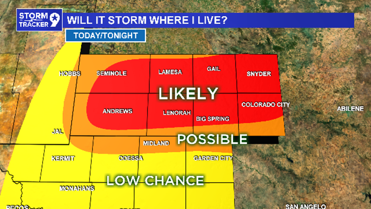
WHERE: The highest chance of severe weather will be in the northern Permian Basin, from Seminole and Andrews east to Snyder and Colorado City, and everywhere in between. As we go south towards Midland-Odessa, the chance for storms decreases, but there is still a chance.
WHEN: From 5pm to 11pm: Storms will likely form around 5-6pm and move eastward from there over the next several hours, exiting our viewing area around 10pm-midnight.
IMPACTS: The strongest storms will be capable of producing large hail, damaging winds, and even an isolated tornado. As always, heavy downpours and frequent lightning will be threats as well.
WHAT TO DO: No reason to panic. Just make sure to stay weather aware if you are in the northern Permian Basin by keeping up with us on Facebook, Twitter, and on-air here on NewsWest 9. Don’t cancel any plans just yet, but make sure to have a plan B if severe weather does strike.