

The start of Meteorological Fall kicked off with record rainfall which led to flash flooding across West Texas that left impacts that will take quite some time to recover from. Throughout West Texas, we had observed rainfall amounts from 0.10 of an inches to 8 inches of rain from Sunday to Wednesday with some areas seeing most of it in just a day. Alot of the coverage was present more east of us but with the rain we did have even in little amounts went A long ways to causing impacts to the Permian Basin.


Most of the activity was seen on Monday with the southern portions of the Basin seeing there share Sunday Night into Monday Morning with specific places like Iraan with their Flash Flood Warning which they saw totals up to 4 inches of rain within 4-hour window. The Northeast part of the Basin like Snyder and Big Spring saw rain totals between 2-4 inches of rain which the NE had more persistent rain which had higher widespread higher rain totals with the exception of Crockett County seeing a lot of the rain on Sunday. The Higher Elevations saw less coverage but more rain into Tuesday as the cold front pushed south allowing for more rain but minimal rain totals under an inch.


Rain totals more central of the Basin stayed isolated but more centralized West of Odessa and just south central of I-20 from the Midland International Airport seeing totals up to 3.50 inches of rain. With this, flooding was a major concern with actually two Flash Flood Warnings in Midland and Ector County at the same time with rainfall rates between 1-2inches of rain per hour which was during Mondays Afternoon which left major impacts to the roadways.

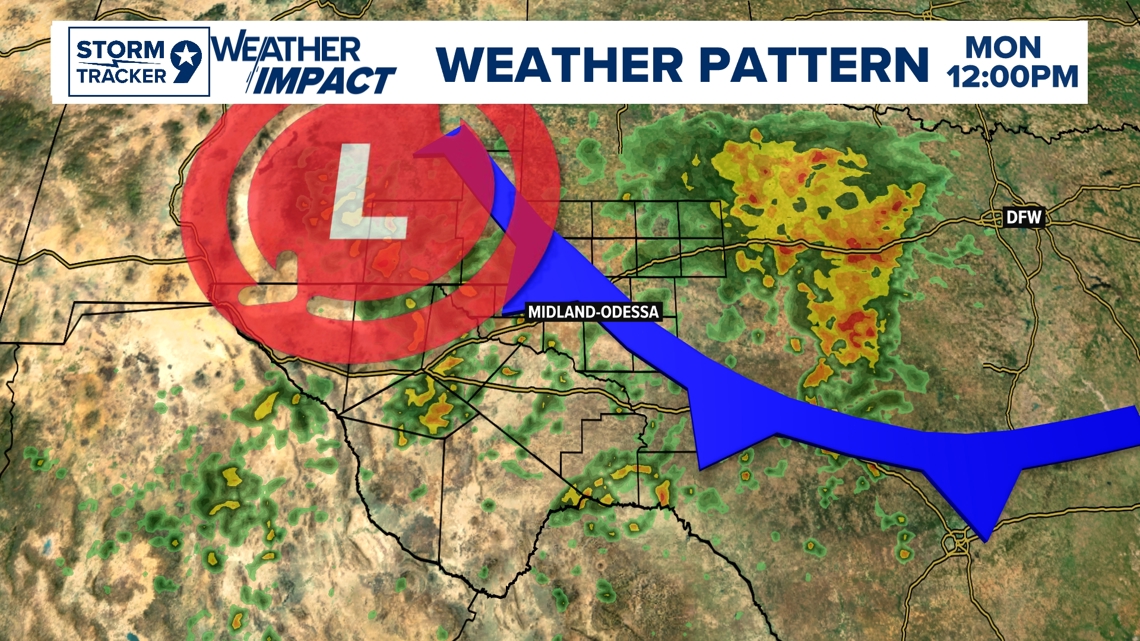
The Weather Pattern was really not on our side and the impacts showed. The Cold Front made its presence into the Basin Late Sunday Night into Monday Morning bringing in the elevated rain chances with it with all the ingredients in play with moisture and instability to have persistent rain. Another factor that really made it against our favor was an Upper-Level Low which had associated energy with its counterclockwise rotation which acted as a lifting mechanism that enhanced the coverage and length of the rain to stay around all day for Monday. As it moved its way east dissipating as the Cold Front turned into a Stationary Front, it moved all the activity East with the current trend of weather for us warming up due to High Pressure dominating the west decreasing rain chances all together.